The
Coming Middle East War of
the Caliphate
Many
of the answers concerning the actual fighting that will take place in
a final Middle East war are found in the bible in Daniel chapter 11
and in Ezekiel 38.
Let's look at the names of the countries mentioned in both text starting with Dan 11.
(words in parentheses are authors notes.)
The nations
listed are
The
King of the North, Libya, Sudan/Ethiopia and Egypt,
Jordan.
*The Hebrew here is "Cush" and is being interpreted as Ethiopia which was just south of Egypt but is more than likely the Sudan now.
Sudan-The
inhabitants of Sudan are divided into three main groups. The
northerners, who inhabit the country roughly north of 12°N lat. and
mainly near the Nile,
consist of Arab and Nubian groups; they
are Muslim (mostly of the
Sunni branch) The
westerners, so called because they immigrated from
W Africa, are also
Muslim The Sudan
boarders both Libya and Egypt.
Ethiopia-The
Oromo, who make up about 40% of the country's population, live
in S Ethiopia and are predominantly Muslim. The pastoral Somali, who
are also Muslim, live in E and SE Ethiopia. The Sudan lies between
Ethiopia and Egypt.
We
see countries listed in Ezekiel 38 of those that will attack Israel
in the end days.
Eze 38:2 Son
of man, set thy face against Gog, the land of Magog, the chief prince of Meshech and Tubal, and prophesy against him,
Eze
38:5 Persia, Ethiopia, and Libya with them; all of them with shield and
helmet:
Eze 38:6 Gomer, and all his bands; the house of
Togarmah of the north quarters, and all his bands: [and] many people
with thee.
Eze 38:13 Sheba, and Dedan, and the merchants of Tarshish, with all the young lions thereof, shall say unto thee, Art thou come to take a spoil? hast thou gathered thy company to take a prey? to carry away silver and gold, to take away cattle and goods, to take a great spoil?
Eze 38:16 And thou shalt come up against my people of Israel, as a cloud to cover the land; it shall be in the latter days, .....
Magog,
Meshech, Tubal, Persia, Ethiopia,
Libya,
Gomer
and Togarmah (north quarters of Turkey), Sheba and Dedan (Arabia)
What Kingdom is being called Gog?
Between the Ezekiel 38 and Dan 11:40 prophecies we are given a list of names of kingdoms involved with Gog/King of the North in the end days war.
Meshech, Tubal, Gomer, Togarmah and Persia, which are all identified as the lands that are north of the Magog.
Edom,
and Moab, Ammon (Jordan), Egypt, Libya, Ethiopia, Dedan and Sheba
(Arabia), Which
are all the kingdoms south of Magog.
And
of course Magog.
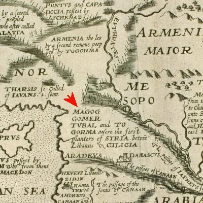
Gog Map
This map shows the old biblical names and the locations from both prophecies.
This leaves a BIG HOLE in our map. One missing kingdom that is located between these Northern and Southern kingdoms that isn't mentioned in these prophecies, and that is the empire of both Assyria/Babylon. This is because the Assyrian/Babylonian kingdom is being called by another name, Ma-gog, which means "land of Gog".
All of the names and places listed above are Muslim countries today and so we can expect the Gog war to be a Muslim war against Israel. I believe this will evolve into a world war and will only be brought to end by Jesus at His return, as shown by the end of both wars, in Ezekiel 39 and the king of the North war of Daniel 12:1 with the resurrection of the dead.
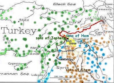
The Table of Nations
Where was the land of Gog located after Babel?
.Gen 10:2 The sons of Japheth; Gomer, and Magog, and Madai, and Javan, and Tubal, and Meshech, and Tiras.
Gen 10:5 By these were the isles of the Gentiles divided in their lands; every one after his tongue, after their families, in their nations.
The word Magog means;
04031 Magowg {maw-gogue'}
from 01463; TWOT 324a;
AV - Magog 4; 4
Magog = "land
of Gog"
n pr m
1) the 2nd son of Japheth,
grandson of Noah, and progenitor of
several tribes northward
from Israel
Tracing the land of Magog is very interesting. The original land, which is what I believe the Lord is referring to concerning the Gog war of Eze 38, was located in upper Syria. they then migrated to Turkey and from there migrated northward between the Baltic and Caspian Seas.
This map of the table of Nations made in 1624 seems to do a very decent job of tracing the Tribes of Japheth over the years.
As you know there are many maps that only show Magog in Turkey or in Southern Russia but there is evidence to support this map as to the original land of Magog being in Syria.
Magog is associated with the name Hierapolis. With the migration of peoples, whether in the Middle East or Europe or the United states we see that when they migrate to a new land they call the new villages or towns by the same names. So many cities in the US, for example have the same name from East to West. Apparently that was the case for Magog.
The city of Hierapolisin western Turkey has been traced to Magog and so also with the city of Hierapolisin in Syria was called by the Syrians Mabog; This city is now called Manbij or Hierapolis Bambyce, an ancient city in the Aleppo Governorate, Syria.
The CRADLE of MAGOG is located
in the NORHERN SYRIAN
city of Hierapolis Bambyce
http://en.wikipedia.org/wiki/Manbij
The place first appears in Greek as Bambyce, but Pliny (v. 23)
tells us its Syrian name was Mabog (also Mabbog, Mabbogh). It was
doubtless an ancient Commagenian sanctuary; but history records it
first under the Seleucids, who made it the chief station on their
main road between Antioch and Seleucia on the Tigris; and as a centre
of the worship of the Syrian Nature Goddess, Atargatis, it became
known to the Greeks as the city of the sanctuary (Ieropolis), and
finally as the Holy City (Ierapolis).
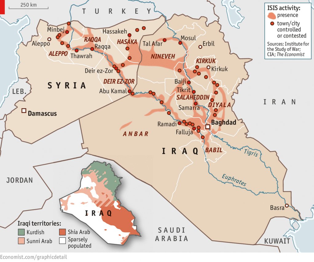
Update 2015. The capitol city of ISIS is Raqqa. This could well be within the territory of ancient Magog. Thus, he would always be called Gog of Magog meaning the land of Gog
Update: 2022. Found this gem. In 796, the caliph Harun al-Rashid chose Raqqa as his
imperial residence. For about 13 years, Raqqa was the capital of the
Abbasid Caliphate, which stretched from Northern Africa to Central Asia ,
but the main administrative body remained in Baghdad. The
Abbasid Caliphate lasted 500 years and was the 7th head of the beast of Rev 13, with the 7 heads and 10 horns.
It was slain but will live again in the future. Explains why ISIS
chose Raqqa as their capital, until they can take Baghdad.
Countries
mentioned in the above Prophecies
Egypt-
94% Muslim (mostly Suuni)
Ethiopia-40%
Muslim/ Sudan- Muslim 70% (Sunni)
Iran-
Muslim (95% Shi'ite Muslim, 4% Sunni Muslim)
Iraq
-Muslim (Sunni and Shi'ite)
Jordan-
92% Muslim (Sunni)
Libya-Muslim,
(mostly Sunni)
Syria- 90%
Muslim (74% Suuni)
Saudi
Arabia- 100% Muslim (mostly Suuni)
Turkey-
98% (mostly Sunni)
One of the things that units these two sects and that is their hatred of the Jews. They all want Israel to disappear.
The terrorist group Al-Qaeda have cells throughout these nations and are 100% Sunni, but under strict sharia laws which govern their political, social, and religious beliefs. ISIS emerged out of Al-Qaeda.
Where
did civilization begin again after the flood?
Not Babylon as we
have been told.
Note:
This information below was gleaned from various web sites on the
subject
The Journey Westward out of Ararat
The
Cradle of Civilization Urartu
(Ararat)
The
Columbia Encyclopedia, Sixth Edition. 2001.
Urartu
(rär´t)
, ancient kingdom of Armenia, centered about Lake Van in present-day
E Turkey. It was the biblical Ararat. Urartu flourished from
the 13th cent. to the 7th cent. B.C., but was most powerful in the
8th cent. B.C., when it
ruled over most of N Syria. The
Urartians constantly fought with Assyria; Shalmaneser I, Shalmaneser
III, and Sargon all attacked Urartu but never completely subdued it.
In the 7th cent. B.C. repeated invasions by the Cimmerians, Scyths,
and Medes finally brought about the downfall of the Urartian kingdom.
Excavations, particularly at such sites as Toprak Kale and Karmir
Blur, have shown that Urartu had an advanced agricultural and
commercial civilization, which was largely influenced by Assyria. The
use of cuneiform was also borrowed from the Assyrians. Urartian
techniques of metalworking and stone masonry (especially in the
construction of fortresses) was highly advanced.
See
B. Piatrovski, Ancient Civilization of Urartu (1969).
"The name was preserved in the Old Testament in the corrupt form 'Ararat,' which in the Latin version became 'Armenia.' When the Massoretic writers were vocalizing the text of the Bible they inserted the vowel "a" into words which were unknown to them, so that 'Urartu' became 'Ararat'; and it is only within very recent years that the Qumran scrolls have yielded a form of the name with the semi-vowel "w" in the first syllable (21)."
Ararat:
sacred land or high land, the name of a country on one of the
mountains of which the ark rested after the Biblical Flood
subsided. The mountains mentioned were probably the Kurdish range of
South Armenia. The word is rendered Armenia in the Authorized
Version but in the Revised Version Land of Ararat. In
Jeremiah
51:27 the name denotes the central or southern portion of
Armenia. It is however generally applied to a high and almost
inaccessible mountain which rises
majestically
from the plain of the Araxes (Aras River).
Two Old Testament references to Urartians are described by Professor Petrovskii as follows:
"A passage
in the Book of Jeremiah dated to the fourth year of the reign of King
Zedekiah
(i.e., 594 B.C.) talks of
calling together against Babylon the Medes, the Urartians
('Ararat'), the Mannaeans
('Minni') and the Scythians ('Aschenaz') (22)."
And
"The Old
Testament preserves a recollection ... that Sennocherib's sons,
having killed
their father, fled to Urartu
(the 'land of Ararat' or 'land of Armenia') (23)."
Today, almost any Bible atlas includes Urartu on its maps of the ancient world and explains that Ararat in the Bible really refers to Urartu
Professor Seton Lloyd, another researcher into Urartu, has this to say about the ancient civilization:
"Urartu is now
being presented to us as a nation--and in its time a very great
nation-whose history and even
identity seem to have been completely expunged from the
records of human memory for
two-and-a-half thousand years. Yet today, everything about
it--its racial characteristics,
political and economic history and its art--constitute it one
of the most intriguing problems
in Near Eastern Archaeology (24)."
The Urartian Culture
It is generally agreed that the Urartians arose from the Hurrians and employed a language similar to Hurrian. These mountaineers built great fortresses on overlooks throughout the highlands of Urartu. Their kingdom supported huge building programs. Palace remains show evidence of economic might. Much of their art has been recovered, particularly works in bronze.
This persistent portrayal of the tree of life with its guarding celestial beings pervaded the Urartian culture.

SACRED TREE OF LIFE WITH ATTENDANTS (Angels).
Extreme stylization of tree indicates that tradition was already ancient. (Urartian, detail of bronze helmet of King Sarduri II, 760-743 B.C. Hermitage Museum, Leningrad).
The Urartians were formidable in war. The Assyrians mounted attacks on Urartian fortresses, but there were periods when they were careful to cultivate the good will of these mountain dwellers. In 714 B.C., for example, Sargon, at the head of his Assyrian army, sacked some Urartian strongholds; but in 654 B.C., the later Assyrian king Ashurbanipal, at the celebration of his victory over King Teuman of Elam and capture of Susa, received emissaries from Urartu's King Rusa. According to Assyrian annals recording the event,
"Rusa, king of Urartu, heard of the mightiness of my gods and was overcome by terror at my majesty. Then he sent his princes to Arbela to bring me greetings (32)."
In 590 B.C., Urartu was sacked and burned. Only hulks remained. The dust and winds of time did their work. It was not until about a hundred years ago that researchers began to connect the ruins throughout the Anatolian highlands with the vague references to Urartu in the Assyrian records; it had previously been believed that they were Assyrian (33). Not until 1936 was the first systematic excavation of a major Urartian fortress begun (34).
After the disappearance of Urartu as a political entity, the Armenians dominated the ancient highlands, absorbing portions of the previous Urartian culture in the process. More recently the Armenians, like their Urartian predecessors, have met tragic and depopulating devastation in these ancestral homelands. The hand of fate seems not yet to have completed its drama of violent readjustment in the Anatolian highlands.
The Bible's account of Noah, the ark, and the Genesis flood states that the ark came to rest on the "mountains of rrt" where "rrt" has been translated "Urartu" or later "Ararat" during Armenian times. At the beginning of the Christian era, Ararat (another version of the Hebrew "rrt" - no vowels in the Masoretic Hebrew text of Genesis") was only a northerly subdivision of Armenia near the Araxes river. During the time of the Old Testament though, the Urartian region was much more extensive (as shown on the map above). From Assyrian texts, Urartu is known to have existed from about the late 13th century BC to the 9th century BC as a loose federation of tribes. However, if one takes a conservative view of Moses writing Genesis in the 15th century BC rather than the 13th century BC, then Urartu would have been known even in that era.
The
Urartian Kingdom existed from the 9th century BC until the 6th
century BC when it was destroyed by the Medes and vanished from
history, only to be rediscovered in the archaeology of the late 1800s
and early 1900s. Thus there exists the possibility of a
mis-interpretation of Genesis by post-Christian writers and Armenians
restricting the Ark's landfall to the smaller Araxes valley area
including Mount Ararat rather than the larger Urartian region or
"mountains of Urartu" as described by Moses in Genesis.
However, some of this is speculation since there are no
cross-references in 15th century BC writing so no one really knows
exactly where Moses was referring to when he stated that the ark came
to rest on the "mountains of rrt".
End
Noah's
children traveled to the west
Gen
11:2
And it came to pass, as they
journeyed from the
east, that they
found a plain in the land of Shinar; and they dwelt there.
In Genesis we find the Ark on Mt Ararat and man migrating west and then southward from the ark.
Then heading east. They most likely followed the
Murat river to the Euphrates river.
That means they traveled west
from Mount Ararat!! That is an important fact in understanding
where the city of UR was located.
Next we read of Abram migrating from Haran;
Harran; Hebrew Haran; (Strong's 02039) name of the place to which Abraham migrated from;
Ur of the Chaldees and where the descendants of Abraham's brother Nahor established themselves; probably located in Mesopotamia, in Padanaram, the cultivated district at the foot of the hills between the Khabour and the Euphrates below Mount Masius
Ur;
called Urfa, is in southeastern
Turkey, former capital of ancient Osrhoene. It is situated on a
limestone ridge, an
extension
of the ancient Mount
Masius in the Taurus
mountains of southern Anatolia (Turkey)
Where were these Chaldeans from?
The evidence shows that their homeland included the area of south central Turkey because inscriptions have been found which tell that both Nebuchadnezzar (2nd king of the Chaldean empire) and Nabonidus (last king of the empire whose son, Belshazzar, was co-regent in Babylon) built temples to "Sin", the moon-god in HARRAN. Inscriptions also show that Nabonidus and his mother were both FROM Harran. The term "Chaldees"- the Urartuans or those from the greater Ararat region, called their collection of gods "khaldis" and their supreme god Khaldi.
"Abraham,
the son of Terah,
the son of Nahor,
the son of Serug,
the son of Reu, the son of
Peleg,
(Luke 3:34)
"When
Terah had lived seventy years, he became the father of Abram, Nahor,
and Haran."
Archaeologists have found that most of the names of his ancestors of his genealogy were names of cities. These names are present in southern Turkey.
Town names of Harran, Nahor, Serug, and Terah
Abram's kin
settled in Syrio-Mesopotamia region between the upper Euphrates and
Habur rivers near Urfa Haran
(Gen 11:31),
Abram
(Old Assyrian text Abrum) whose father was Terah,
(Til-Sa-Turahi, "Mound of Terah," Neo-Assyrian text),
grandfather Nahor,
as is his brother, whose name is from Old Assyrian and Old Babylonian
texts Til-Nakhiri (the "Mound of Nahor", Neo-Assyrian text)
and great-grandfather Serug,
Sarugi, Neo-Assyrian text) . Peleg
recalls later Paliga on the
Euphrates just above the mouth of the Habur.
These
are place-names
referring to sites in the plain of Harran.
This
area during Genesis was identified as Aramean by the terms
Aram-Naharaim [(Final Mem Yod Resh He Nun Final Mem Resh Aleph
Lamed Aleph) literally "Aram of the two rivers, (Shinar)."
Over a 1000 years after the tower of Babel was built near Ur (Urfa) we can see (on the map above) the Chaldeans have moved south along the rivers into the place they called Babylon. They also named a city that they built there UR.
So to sum up, The families of Noah migrated, first traveling from the east toward the west following the river through the mountains until they came to a huge open plain they named Shinar, meaning land between the two rivers, (The Plain of Harran). They settled in the plain (area in Yellow) in southeast corner of Turkey and northern Syria. Then the generations began to migrate down the Euphrates and Tigris Rivers. Asshur built the cities of Assyria, Nineveh and other cities (Iraq). God uses these ancient names to identify the original lands of these peoples, not where they migrated to over a long period of time, but where they first settled and land of Gog is a small section of those lands. Where exactly nobody knows for sure.
The Evidence of the Birth of All Languages
Quote: To comprehend events of the past, it helps to place ourselves in their "shoes". For a moment, let's consider a town where suddenly many, many different languages are being spoken. In the confusion, what would you do? First of all, everyone would find those who speak their own language. Then, decisions would have to be made about what to do next. If you've ever been to a foreign country where you don't speak the language, you'll realize that it would be almost impossible to live side by side and continue building, planting, harvesting, etc. with those whom you can't communicate with. Especially back then when there were no translators.
The first order of business would most likely be to find a separate place to live. You'd need room to raise crops: fields for your flocks; and room to begin to build a permanent settlement. Some language groups may set out and settle 25 miles from the original town while others would have to travel 100 or even more before they could find a suitable location. As time passed, the land nearby would already be taken and new groups would have to travel further and further away to find a suitable location. Some would perhaps be more ambitious and travel much, much further- perhaps 1,000 miles away. But as with all things, there would remain remnants of many, many of the original language groups in the general area.
And today,
nowhere else on earth can you find so many different tongues being
spoken in such a small area: "Many ancient races and tribes
still inhabit the Caucasus [the mountains above Noah's Ark which form
the northern barrier of the Araxes plain] and the Armenian plateau of
eastern Anatolia. As many as fifty different languages and dialects
are spoken in this vast and, in parts, inaccessible region."
(LW, p. 137). " Strabo informs us (Book XI, 5), that no less
than seventy Dialects were spoken in the country, which even then was
called the Mountain of Languages" (LH, col. VIII, p. 6,743.) The
further one travels from this area, the fewer languages we find being
spoken in an area (with the exception of cases of immigration, such
as in the US.) This evidence alone is sufficient to show where the
languages began.
End
Quote:
The
first alphabet
Quote;
Among the more important
discoveries at Ugarit are tablets from the 14th cent. BC Written in a
cuneiform script, in a hitherto unknown language,
Ugaritic, they
record the poetic works and myths of the ancient Canaanites. They are
written in an alphabet that is one of the earliest known. Ugaritic
has been identified as a Semitic language, related to classical
Hebrew, the language of the Old Testament, and these tablets, the
first authentic specimens of pagan Canaanite literature, have been of
great importance to students of language and of the Bible. They offer
evidence that the stories of the Old Testament were based on written
Canaanite documents as well as being passed down orally. They
were perhaps the first to recognize that human speech consists of
only a finite number of atomic sounds and all that was really needed
was a symbol for each. They devised 30 symbols from which the
alphabets of all phonetic languages are derived (yes all: Hebrew,
Latin, Sanskrit, Aramaic, Arabic, Greek, etc.). As a result, writing
opened up and scribal power reduced; any child (or foreigner) could
now easily learn to read and write. This may sound simple but it took
nearly two millennia to arrive at it. In Histories,
Herodotus acknowledged that the Greeks got their alphabet from the
Phoenicians. (Canaanites, precursors to the Phoenicians) The names of
most letters in the Greek/Phoenician alphabets are clearly related –
alpha/aleph
(ox), beta/bet
(house), gamma/gimel
(camel), delta/dalet
(door), etc. Notably, the
Ugaritic alphabet only had consonants – the pre-Homeric Greeks
added the vowels.
-------------------------------------------------------------------------------------------------------
I
also researched sites on the study of languages and it is agreed that
this is the area, below where the ark came to rest, is where the
different languages began and spread outward into the world. So
the tower of Babel was built between the two
rivers in the plain of Shinar.
The following is taken from the work of Dr. Carl Ludwigson "A Survey of Bible Prophecy":
Ezekiel's Gog is the enemy from the north. In the Old Testament, the king of the north has reference to the areas of Syria, Turkey, and Iraq. The word north is used of Syria or the Old Seleucid Empire six times, of Babylon sixteen times, of Assyria one time, and of Iran one time. These are the lands once occupied by Ma-gog, Gomer, Togarmah, Meshech and Tubal.
Meshech, Tubal, Togarmah, and Syria traded with Tyre six centuries before Christ [Ezek.27:13-16]. These lands clearly define the north. The fact that some scholars equate the names of ancient Middle East cities with modern English cognates is appalling. Meshech is NOT Moscow; Moscow just had its 850th birthday.
Some have interpreted the Hebrew word 'rosh' in Ezekiel 38:3, which is translated 'chief', to be a reference to Russia. In the Massoretic text the words 'chief prince' carry the accents Tiphha and Zaqeph-gadol. The Tiphha appears under the resh of the Hebrew word 'rosh'; the Zaqeph-gadol appears on top of the sin of the Hebrew word 'nish'.The Tiphha to the right, underneath the initial consonant of the word 'rosh', or chief, is prepositive and does not mark the tone syllable. See Kautsch and Cowley's *Grammar*, page 61 item 9.
The word 'nish' or prince has the accent Zaqeph-gadol which is disjunctive and indicates a pause. See Kautsch and Cowley's *Grammar*, page 60 item 4b.
So Ezekiel 38:3 should be read as follows: "Behold, I am against thee, O Gog, the prince, {pause} chief of Meshech and Tubal:" Rosh is not Russia.
The Hebrew word 'rosh' is translated head or chief 423 times in the Old Testament. Again, it is absolutely appalling how some scholars can equate the English cognate 'rosh' with Russia. Rosh is not Russia. End
Gog will be the Caliph of an Islamic Caliphate
Return Home